West · Walking
Walking the Samaria Gorge
Sixteen kilometres downhill from the White Mountains to the sea, one-way and no shortcuts. It earns its name — but go in knowing what the day costs your knees.
The first thing to understand about the Samaria Gorge is that it is not a loop, not a stroll, and not something you wander into after a late breakfast. It is a 16 km descent through the Lefka Ori — the White Mountains — beginning at roughly 1,230 metres on the Omalos plateau and ending at the edge of the Libyan Sea. You start high and cold, finish low and salt-stained, and cannot drive back the way you came. That single fact shapes the whole day.
It ranks among the longest gorges in Europe, and for stretches you will believe it. Walls climb, light narrows, footsteps echo. Then it opens out again into pine and oleander, and you remember you are tired.
The early bus, and why you take it
Buses leave Chania and Rethymno in the dark, give or take. Most pull out between roughly 07:00 and 08:00 and climb the switchbacks up to Xyloskalo, the trailhead on the Omalos plateau. The hour is not for atmosphere — it is arithmetic. You have a ferry to catch at the far end, and the gorge does not wait. Miss the morning departure and you will be walking against the clock, which is the one reliable way to make a hard day genuinely unpleasant.
Our notes on getting around Crete cover the seasonal timetables and where to actually buy the ticket. Book the day before in high summer; the popular departures fill.
At the top there is a small park entry fee — a few euros, paid at the gate. Keep the ticket. They count tickets at the bottom to make sure nobody is left somewhere in fourteen kilometres of rock — a sobering detail, and the reason you should not improvise your own exit.
The wooden stairs, and the long way down
Xyloskalo means "wooden stairs," and the first kilometre lives up to it: a steep, zig-zagging descent with a handrail, dropping fast off the plateau. Most of the day's knee damage gets done here, oddly enough — at the start, while you are fresh and tempted to go quickly. Don't. A trekking pole earns its place here more than anywhere.

Gradient eases after the stairs. The path follows a riverbed — dry in high summer, very much not dry in spring — criss-crossing the stream on stones and the occasional plank. Halfway down you reach the old village of Samaria, abandoned by its last residents in 1962 when the gorge became a national park. A few stone houses still stand, used now by the wardens, with shade and a water point. It is the natural place to stop, eat what you carried in, and reckon with how much leg you have left.
A word on what to carry. You do not need a week's supplies, but you do need water — springs and refill points line the route, so one refillable bottle beats hauling a litre from the top — and you need proper shoes. The riverbed is loose stone and polished rock. Every season the wardens watch someone attempt it in flip-flops, and every season that person regrets it by the Iron Gates. Sun hat, a snack, a little cash for the taverna. That is the kit.
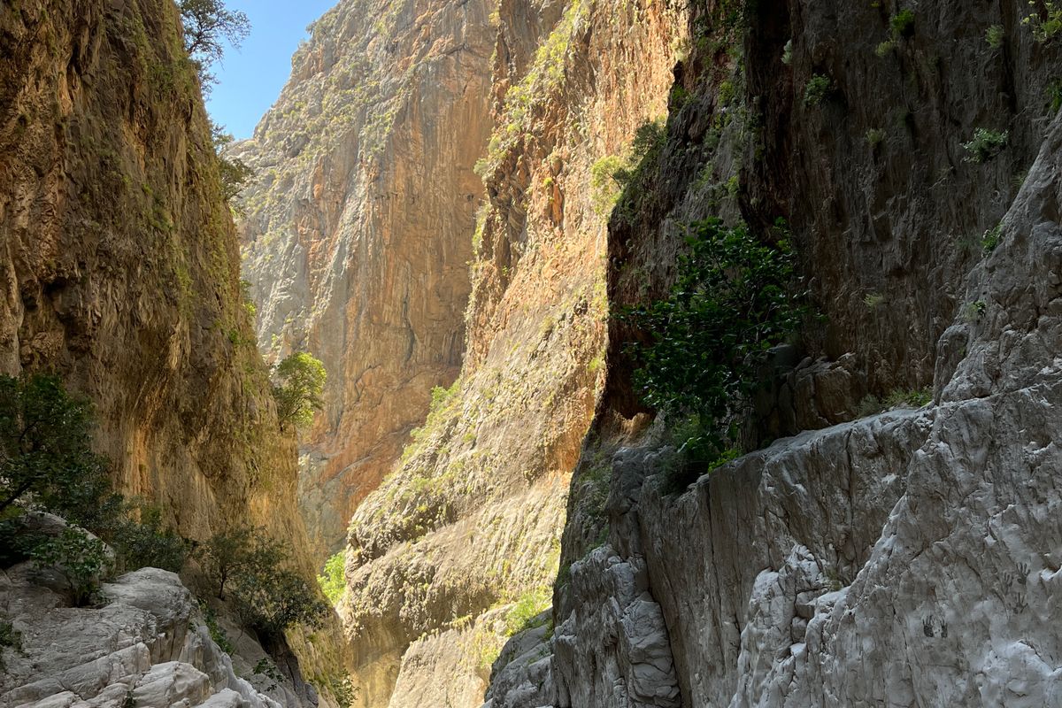
The Iron Gates, where the walls almost touch
This is the part everyone comes for, and it does not disappoint. Near the lower end the cliffs pinch together at the Sideroportes — the Iron Gates — until the passage is roughly three to four metres wide, with rock rising hundreds of metres straight up on either side. You walk through a slot. Temperature drops, light goes blue, and for a few minutes the scale of the place stops being an abstraction.
You spend hours thinking the gorge is the long brown corridor of rubble and pine. Then the walls lean in at the Iron Gates and you finally understand what carved this — water, patiently, for longer than is comfortable to think about.
Watch the higher ledges through the day. The gorge is the last real stronghold of the kri-kri, the Cretan wild goat, and most of the free-living population lives on these slopes. No guarantees — but that still, side-stepping shape on a rock shelf you almost take for a boulder is usually one.
Out at Agia Roumeli, and the boat you can't skip
The gorge proper ends a few kilometres short of the coast, and the last stretch is a hot, flat, slightly demoralising walk along an open track to Agia Roumeli. There is a beach. There are tavernas. There is, crucially, no road out — the mountains cut the village off from the island, so you arrive on foot and leave by sea.
Field note — the one-way logistics. Samaria is point-to-point. From Agia Roumeli you take a ferry along the south coast, then a bus back over the mountains. Plan it before you set off, not after.
- Eastbound: ferry to Loutro and Chora Sfakion, then a bus to Chania or Rethymno.
- Westbound: ferry to Sougia and Paleochora, then a connecting bus.
- Timing: the buses are built around the last afternoon boats — be at the harbour early, not on the dot. Sailings are weather-dependent and can be cancelled.
Check current sailings with the south-coast operator, ANENDYK, before you travel — times shift with the season and the seas.
The harbour town of Chania is the obvious base: most organised buses run from there, and it is a soft landing for legs that have just done sixteen downhill kilometres.
Is it worth it? An honest verdict
Yes, with conditions. It is long, the descent is relentless, and your knees will file a complaint around hour four. This is not a gentle nature walk, and the marketing that frames it as one does nobody any favours. Allow five to seven hours of moving, more if you stop properly, and treat it as a full day.
But it earns the reputation. The Iron Gates alone justify the early alarm, and walking from snow-line scrub to a swim in the Libyan Sea inside one day is its own quiet reward.
Two practicalities to close on. The gorge is seasonal — roughly May to mid-October, shut through winter and early spring — and the park will close it mid-season after heavy rain or in dangerous heat, so confirm it is open before you commit to the bus. And if the full descent sounds like more punishment than holiday, there is a respectable cheat: ferry to Agia Roumeli, walk a few kilometres up to the Iron Gates, then turn around. Best scenery, none of the knee work. No shame in it — the gorge will still be there, and so, with luck, will your cartilage.
- Open season: approximately May through mid-October; closed in winter and after heavy rain.
- Distance and time: 16 km, one-way, downhill; allow 5–7 hours moving.
- Getting out: ferry from Agia Roumeli, then a bus — there is no road.
- Kit: proper shoes, water bottle, sun protection, small cash, a pole for the stairs.
For a second opinion on planning, Lonely Planet's gorge write-up is sound, and the national park listing is where to sanity-check opening dates before booking.